


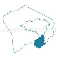
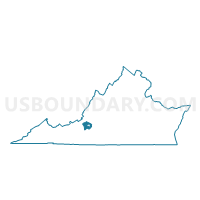
Clearbrook Voting District, Roanoke County, Virginia
About
Outline

Summary
| Unique Area Identifier | 682441 |
| Name | Clearbrook Voting District |
| County | Roanoke County |
| State | Virginia |
| Area (square miles) | 18.50 |
| Land Area (square miles) | 18.49 |
| Water Area (square miles) | 0.01 |
| % of Land Area | 99.95 |
| % of Water Area | 0.05 |
| Latitude of the Internal Point | 37.17600560 |
| Longtitude of the Internal Point | -79.96255970 |
Maps

Graphs
Select a template below for downloading or customizing gragh for Clearbrook Voting District, Roanoke County, Virginia


Neighbors
Neighoring Voting District (by Name) Neighboring Voting District on the Map
- Bonbrook Voting District, Franklin County, VA
- Boones Mill Voting District, Franklin County, VA
- Bowmans Voting District, Franklin County, VA
- Cotton Hill Voting District, Roanoke County, VA
- Garden City Voting District, Roanoke city, VA
- Hunting Hills Voting District, Roanoke County, VA
- Mount Pleasant Voting District, Roanoke County, VA
Top 10 Neighboring County Subdivision (by Population) Neighboring County Subdivision on the Map
- Roanoke city, Roanoke city, VA (97,032)
- Vinton district, Roanoke County, VA (17,818)
- Cave Spring district, Roanoke County, VA (17,614)
- Boone district, Franklin County, VA (7,793)
- Blackwater district, Franklin County, VA (7,675)
Top 10 Neighboring Place (by Population) Neighboring Place on the Map
Top 10 Neighboring Unified School District (by Population) Neighboring Unified School District on the Map
- Roanoke City Public Schools, VA (97,032)
- Roanoke County Public Schools, VA (92,376)
- Franklin County Public Schools, VA (56,159)
Top 10 Neighboring State Legislative District Lower Chamber (by Population) Neighboring State Legislative District Lower Chamber on the Map
- State House District 9, VA (82,064)
- State House District 8, VA (74,460)
- State House District 17, VA (73,149)
Top 10 Neighboring State Legislative District Upper Chamber (by Population) Neighboring State Legislative District Upper Chamber on the Map
- State Senate District 22, VA (193,582)
- State Senate District 21, VA (188,365)
- State Senate District 19, VA (186,272)
Top 10 Neighboring 111th Congressional District (by Population) Neighboring 111th Congressional District on the Map
Top 10 Neighboring Census Tract (by Population) Neighboring Census Tract on the Map
- Census Tract 205, Franklin County, VA (8,135)
- Census Tract 306, Roanoke County, VA (7,298)
- Census Tract 203, Franklin County, VA (6,127)
- Census Tract 204, Franklin County, VA (5,448)
- Census Tract 28, Roanoke city, VA (5,414)
- Census Tract 309, Roanoke County, VA (5,386)
- Census Tract 29, Roanoke city, VA (5,130)
- Census Tract 310, Roanoke County, VA (3,856)